The European Space Agency launched its Mars Express mission in 2003, with the spacecraft entering orbit around Mars on Christmas Day that year. Its landing component, Beagle, unfortunately malfunctioned, but the Express orbiter completed a Martian year in orbit (its planned life cycle) in 2005. The ESA subsequently decided to keep it in operation for a second Martian year, since the results from the first year had been so promising and the hardware showed no signs of wearing out.
Mars Express has produced some truly spectacular photographs of the Martian surface. I’ve reproduced a few here in reduced size, and beneath each one I’ve included a link to a high-resolution shot on the ESA Web site. Some of these are very large indeed (I’ve indicated the size in megabytes for each picture), so if you’re using dial-up Internet access I’d recommend against clicking on the links. (All photographs are copyrighted by ESA, but permission for educational use such as this is given by the Agency.)
(NOTE: The images displayed here will enlarge if you click them, but not to the full high-resolution size available on the ESA Web site. To obtain the latter, click the link below each image, then click the image when it’s displayed for the full-size version.)
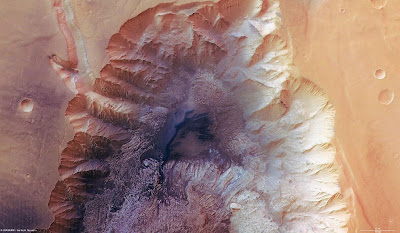
First, here’s the northern part of Hebes Chasma in the Valles Marineris region at 1° S 282° E. It’s approximately 26,000 feet deep (kinda dwarfs the Grand Canyon, no?) and is believed to have once contained flowing water. In this picture, one pixel on your screen (in the high-resolution image linked below the picture) equates to almost 50 feet on the ground.
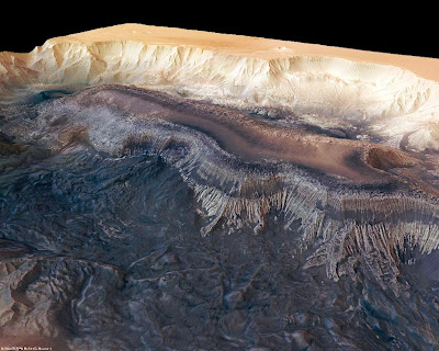
Here’s a perspective view of part of Hebes Chasma.
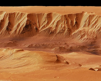
Next we have Candor Chasma, another deep valley in the Valles Marineris at 6° S 290° E. It’s almost 28,000 feet from the floor of the valley to the rim – in other words, if Mount Everest were stood in the middle of the valley its peak would be less than 2,000 feet above the rim!
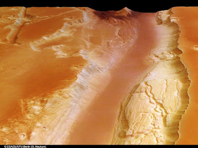
Next we have Kasei Valles, one of the largest outflow systems on Mars, located between 21°-28° N and 292.5° E. It’s theorized that these immensely deep channels (over 8,000 feet from bottom to rim) were formed by a combination of flowing water and glacial activity. This picture shows a perspective shot of the southern branch.
Then there’s the famous “happy face” crater, officially known as Crater Galle. When photographed decades ago by low-resolution cameras from early Mars orbiters it resembled a smiling face, leading to all sorts of speculation by non-scientists that it was of intelligent origin, a creation designed to send a message. Of course, that’s not true, and the high-resolution photographs from Mars Express show clearly that the features resembling eyes and a mouth are purely and simply geological and geographical phenomena – but it made a nice story while it lasted! The crater is at 51° S 329° E, and is about 144 miles across.
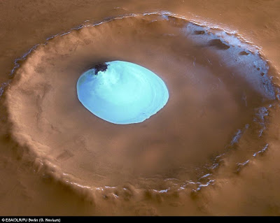
Finally, here’s a wonderful shot of water ice in a crater near the Martian North Pole. The ice is visible year-round. The crater is in the Vastitas Borealis plain at 70.5° N 103° E, and is about 22 miles wide with a maximum depth of about 6,500 feet.
There are many more photographs and descriptions at the ESA Web site. Highly recommended if you have the time and inclination to browse.
Peter

Hebes Chasma looks like a meringue gone very wrong.
*Splutter!* *Choke!*
(Wipes tea-spray off monitor.)
Phelgm, you’re incorrigible! Comparing a Mars landscape to a flopped meringue! 🙂
I can only hope the ESA scientists never read your comment. It might drive them to distraction! (Hee-hee!)
…flopped and rather over-cooked, for all that. And, I’m sure even a failed meringue could manage to be impressive. Fortunately for mouthy insipid Texas women, ESA scientists have bigger fish to fry.