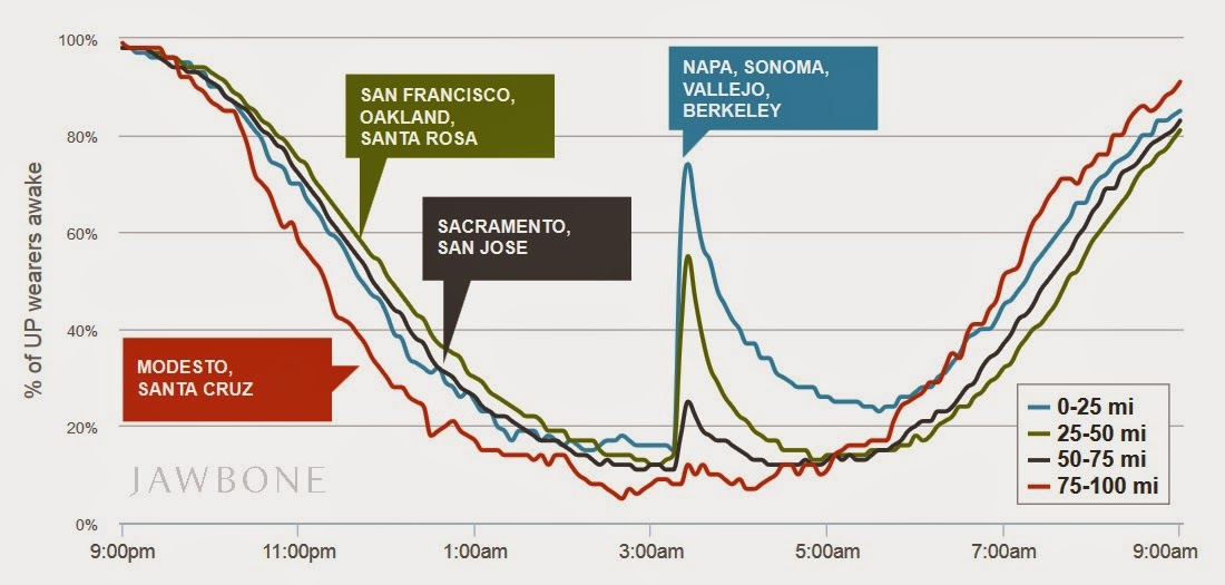
I was amused, and also interested, to read that the recent California earthquake was monitored very accurately by Jawbone, a fitness tracker log. Ars Technica reports:
Wearable computing company Jawbone released a graph on Monday showing its users being woken up by the 6.0-magnitude earthquake centered in the Napa Valley region of California on Sunday morning. 120 people were injured, a lot of wine went to waste, and a few people wearing Jawbone’s Up fitness bands lost some sleep, according to a huge spike in the percentage of users who were up and moving in affected regions at about 3:20am (close to 80 percent in Berkeley, Vallejo, and Napa Valley itself).
The graph accurately plots the nexus of the earthquake, with smaller spikes of activity in more distant regions, including San Francisco and Oakland (around 60 percent of users), Sacramento and San Jose (25 percent), and Modesto and Santa Cruz, with only a tiny bump of a few percent from the baseline. Together, the locations form a basic map of the earthquake’s reach, not dependent on scientific measurements and existing equipment waiting for a disaster, but just a large, distributed population wearing tracking devices.
There’s more at the link.
I’d never have thought that a fitness tracker app would be able to provide almost real-time feedback on where and how intensely an earthquake was felt. I wonder if the USGS has considered contracting with Jawbone and other app companies to see whether this can be more widely used? (Of course, it also has implications for individual privacy, but if the data is aggregated as Jawbone did in its graph, those risks should be minimized.)
Peter

And the Sheep Look Up
Phones are bad enough, but this would give them even more 'tracking' capability… sigh
I bet dollars to doughnuts that at least one USG agency is already tracking through that app. That's one of the reasons they needed that big new data center near SLC.