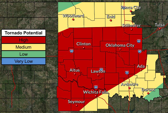
It looks like this part of the country, as well as points north, are in for a torrid time of it this evening. As the weather map below shows, the “dry line” blew up a couple of hours ago, and a line of severe storms is marching eastwards towards us. We expect them to arrive by middle to late evening.
Hurricane-force wind gusts, hail up to softball size, and flash flooding are in our forecast; and we’re under a tornado watch as well.
It’s likely to be an “interesting” night, in the sense of the fabled Chinese curse! Please keep this entire area in your prayers. Locals have long memories of earlier weather disasters, and they’d greatly prefer to avoid another one.
EDITED TO ADD: Residents of Wellington, TX are reporting baseball-size hail earlier today. This photograph’s making the rounds of social media.
I’ll pass, thanks, if given the opportunity!
Peter


Yeah, batten down the hatches. Stay safe!
They aren't the ONLY ones that don't want interesting times again.
Up in CO we have been having light rain, but the forecast is for it to turn into snow around 10 PM. Pray you guys will be safe, and the hail and tornadoes stay away from your location.
It's 2230 EDT, I hope things are ok for you.
Damn! Ok City looks like it has a bulls-eye on it again, then up thru Tulsa and on to Joplin. Y'all stay safe in that neck of woods!
Glad I'm sitting this tornado season out in the land of the Phoenix.
Snowing here in Colorado Springs tonight. I will take that over the hail and wind anytime.
Odd weather here, N/E of San Jose. Had to fire up the heater a couple days ago. 45*F noon Sunday, pouring rain with thunder booming, road flooding, and when I walk into the kitchen, the back yard is getting hail, pea sized. So much came down it was looking like snow on the ground. Clogged up the roof gutters, and left a couple inches on the back deck.