Hurricane Ike has grown so large in diameter that it’s already sending rain and storm winds into central Louisiana. I’ve just looked out of my front door (at 4.15 a.m.) and it’s raining and blowing hard. Given our existing hurricane damage from Gustav, we may have a tough time of it for a while.
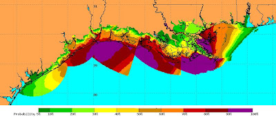
Coastal storm surge and flooding is likely right along the northern coast of the Gulf of Mexico, from southern Texas right through to the Alabama/Florida border. This composite image, derived from two NOAA maps, shows the areas that may be affected.
My own area of Louisiana is under a tropical storm warning, flash flood warning and tornado watch from now until Saturday morning. We’re in the brown/orange band area, with a 50%-60% likelihood of tropical-storm-force winds.
We’ve been advised to prepare for power losses and other damage. According to the National Weather Service warning:
THIS STATEMENT RECOMMENDS ACTIONS TO BE TAKEN BY PERSONS IN THE
FOLLOWING COUNTIES OR MARINE AREAS:ACADIA…ALLEN…AVOYELLES…EVANGELINE…JEFFERSON DAVIS…
LAFAYETTE…LOWER ST. MARTIN…RAPIDES…ST. LANDRY…UPPER ST.
MARTIN…VERNON.…WATCHES/WARNINGS…
THE FOLLOWING WATCHES AND WARNINGS ARE CURRENTLY IN EFFECT FOR
THIS AREA:FLASH FLOOD WATCH.
TROPICAL STORM WIND WARNING.…PRECAUTIONARY/PREPAREDNESS ACTIONS…
PERSONS SHOULD PREPARE FOR THE POSSIBILITY OF TROPICAL STORM FORCE
WINDS WHICH MAY RESULT IN POWER OUTAGES…BLOWN DOWN TREES…AND
SOME ROOF DAMAGE TO HOMES AND BUSINESSES.…WINDS…
TROPICAL STORM FORCE WINDS OF 35 TO 45 MPH WITH GUSTS TO 65 MPH
WILL BEGIN LATER TONIGHT…AND PERSIST THROUGH FRIDAY…BEFORE
DECREASING BELOW TROPICAL STORM FORCE BY SATURDAY MORNING.…PROBABILITY OF HURRICANE/TROPICAL STORM CONDITIONS…
THE PROBABILITY OF HURRICANE FORCE WINDS IS 20 PERCENT.
THE PROBABILITY OF TROPICAL STORM FORCE WINDS IS 60 TO 80 PERCENT.…INLAND FLOODING…
AREAL RAINFALL TOTALS FROM 2 TO 5 INCHES WITH ISOLATED AMOUNTS TO
AROUND 10 INCHES ARE EXPECTED. ADDITIONAL RAINFALL WILL PRODUCE
FLOODING ALONG RIVERS…FLASH FLOODING WITH HEAVIER RAINBANDS.MINOR TO MODERATE FLOODING IS EXPECTED ALONG THE MERMENTAU RIVER
AS WELL AS THE VERMILION RIVER NEAR SURREY STREET IN LAFAYETTE.
SIGNIFICANT FLOODING CAN BE EXPECTED ALONG THE LOWER VERMILION
RIVER SOUTH OF LAFAYETTE DUE TO STORM SURGE TRAVELING UPSTREAM.…TORNADOES…
ISOLATED TORNADOES ARE POSSIBLE FROM FRIDAY INTO SATURDAY.
So, if we lose power and/or telephone lines again, expect this blog to be silent for a few days until they’re restored. Hopefully it won’t be that bad, but with hurricanes one never knows! I’m just glad I got the damaged tree down before it could possibly fall on the house. I’ll sleep easier now that’s been done.
Good luck to those more directly in Ike’s path. Stay safe!
Peter


Stay Safe. I am praying for everyone in Ike’s path.